Yadkin River State Trail Maps and River Accesses
The Yadkin River State Trail is a 163-mile paddle trail with multiple put-in and take-out areas for easy access to the river. It was officially authorized as a state trail in 1985. Cube Yadkin Generation funded the development of the map through a grant to NC Division of Parks and Recreation (State Trails) as part of its FERC relicensing recreation plan. NC State Trails contracted with Yadkin Riverkeeper, who worked with the Piedmont Triad Regional Council and stakeholders along the River to produce both the online and printed maps.
You can see the overview of the trail and the interactive story map below or online here.
To view and download the full map, please click the images below:


1) Mile 163 - Tailwater Access (Kerr Scott Dam)

Address:
GPS Coordinates:
Maintained By:
Phone:
Parking:
Facilities:
Camping:
Entry Type:
Next Access:
Miles to Next Access:
Time to Next Access:
202 Ranger Rd, Wilkesboro, NC 28697
36.136526, -81.222138
US Army Corps of Engineers
(336) 921-3390
Paved Lot (8 spaces)
Bathroom
None
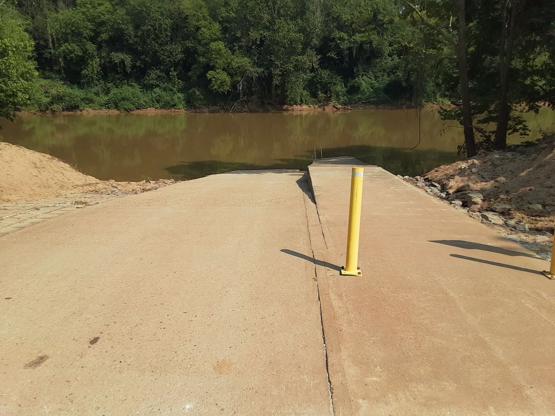
Concrete ramp
Smoot Park
6.8 Miles
2.5 Hours
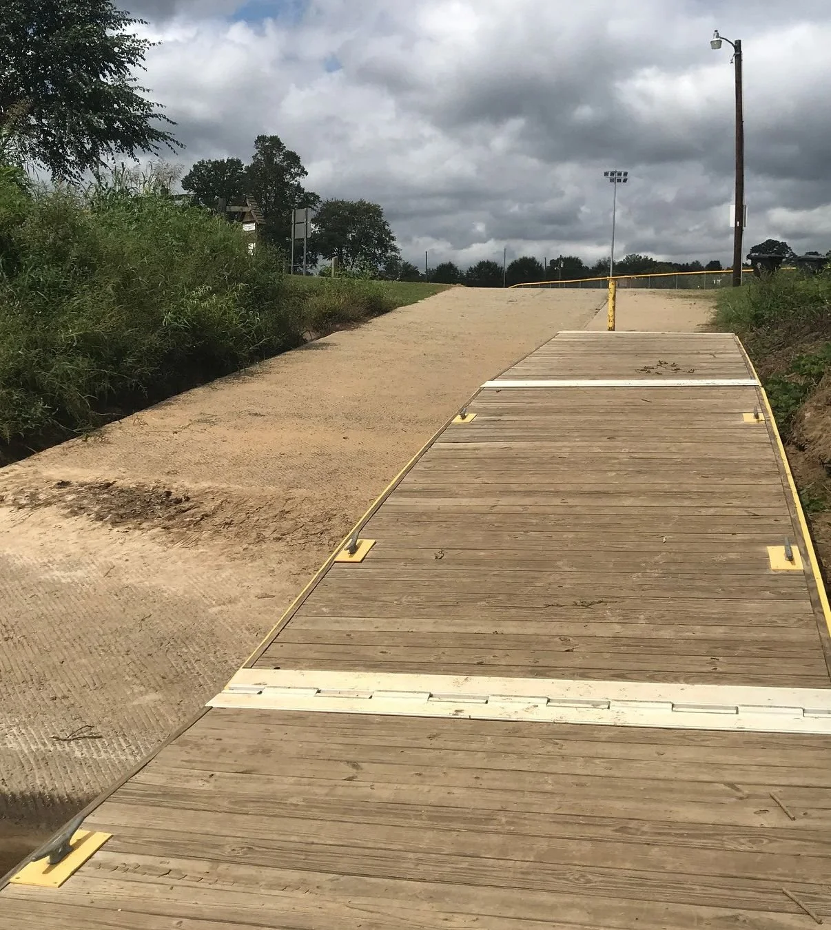
2) Mile 156 - Smoot Park (North Wilkesboro)

Address:
GPS Coordinates:
Maintained By:
Phone:
Parking:
Facilities:
Camping:
Entry Type:
Next Access:
Miles to Next Access:
Time to Next Access:
202 Chestnut St, North Wilkesboro, NC 28659
36.163400, -81.134499
North Wilkesboro
(336) 838-3359
Gravel lot
Bathroom, Picnic, Playground
None
Hand Carry; Steps (#1) and gravel ramp (#2)
Roaring River
10.5 Miles
3.5 Hours
3) Mile 145 - Roaring River Access

Address:
GPS Coordinates:
Maintained By:
Phone:
Parking:
Facilities:
Camping:
Entry Type:
Next Access:
Miles to Next Access:
Time to Next Access:
9214 Elkin Highway, Roaring River, NC 28669
36.205925, -80.984027
NC Wildlife Resources
(336) 651-7501
Small gravel lot
None
None
Gravel ramp
Ronda Memorial Park
5.2 Miles
2 Hours
4) Mile 140 - Ronda Memorial Park

Address:
GPS Coordinates:
Maintained By:
Phone:
Parking:
Facilities:
Camping:
Entry Type:
Next Access:
Miles to Next Access:
Time to Next Access:
238 Clingman Rd, Ronda, NC 2860
36.215930, -80.937172
Town of Ronda
(336) 835-2061
Small Paved Lot
Porta-Potty, Picnic, Playground
None
Concrete boat ramp
Crater Park (Elkin)
7.0 Miles
2.5 Hours
5) Mile 133 - Crater Park (Elkin)
Address:
GPS Coordinates:
Maintained By:
Phone:
Parking:
Facilities:
Camping:
Entry Type:
Next Access:
Miles to Next Access:
Time to Next Access:
310 Standard St, Elkin, NC 28621
36.241717, -80.847351
Town of Elkin & NC Wildlife Resources
(336) 258-8917
Large gravel lot
Bathroom (sometimes locked)
Allowed (but no designated sites/pads)
Concrete boat ramp and dock
Burch Station
6.1 Miles
2 Hours
*Showers available at the Yadkin Valley Heritage and Trails Visitor Center, located at 257 Standard Street in Elkin (M-F 9am-5pm).
6) Mile 127 - Burch Station (at Mitchell River)

Address:
GPS Coordinates:
Maintained By:
Phone:
Parking:
Facilities:
Camping:
Entry Type:
Next Access:
Miles to Next Access:
Time to Next Access:
116 Greenwood Circle, Elkin, NC 28621
36.275577, -80.768861
Surry County & NC Wildlife Resources
(336) 401-8235
Large gravel lot (13 spaces)
None
None
Hand Carry; Wooden steps
Yadkin Shores
4.7 Miles
1.5 Hours
7) Mile 122 - Yadkin Shore Access (at US-601)

Address:
GPS Coordinates:
Maintained By:
Phone:
Parking:
Facilities:
Camping:
Entry Type:
Next Access:
Miles to Next Access:
Time to Next Access:
8420 US 601, Boonville, NC 27055
36.269781, -80.720338
Yadkin County and NC Wildlife Resources
(336) 849-7909
Small gravel lot (7 spaces)
None
Allowed (but no designated sites/pads)
Concrete ramp
Shoals (Pilot Mnt State Park)
16.9 Miles
5.5 Hours
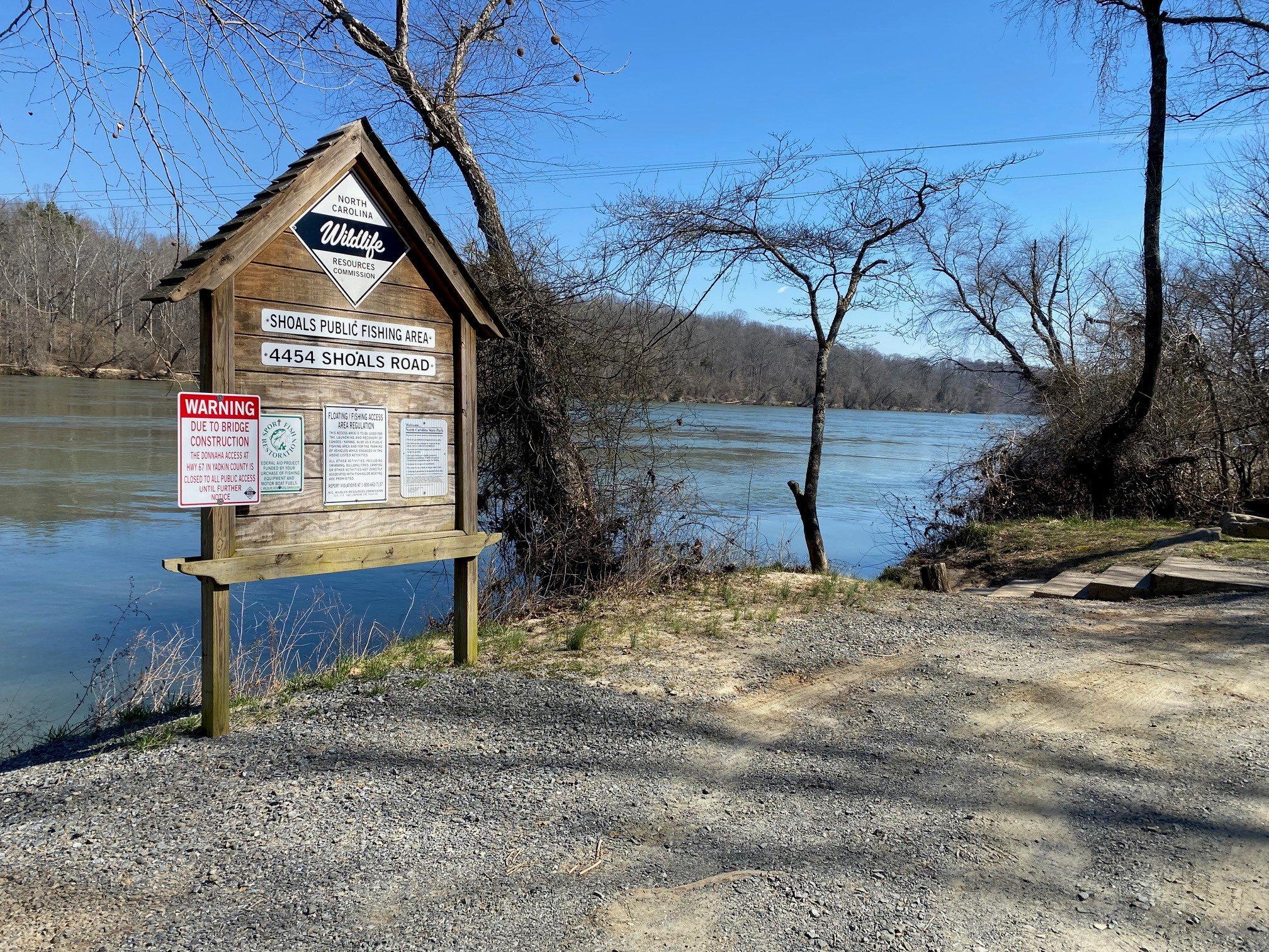
8) Mile 105 - Shoals (Pilot Mountain State Park)
Address:
GPS Coordinates:
Maintained By:
Phone:
Parking:
Facilities:
Camping:
Entry Type:
Next Access:
Miles to Next Access:
Time to Next Access:
4454 Shoals Rd, East Bend, NC 27018
36.257547, -80.517135
Pilot Mountain State Park & NC Wildlife Resources
(336) 444-5100
Small gravel lot
None
Allowed*
Hand Carry; Steps
Donnaha (Closed Spring 2021 to Fall 2023)
6.9 Miles
2.5 Hours
*Camp sites are 0.8 miles downstream at a secondary river access on river right. There are two primitive campsites which are timber pads with gravel screenings. Pit toilet only.
9) Mile 99 - Donnaha (Dam Portage)

**Note: Access closed March 15, 2021 through Fall 2023 to replace Hwy 67 Bridge over Yadkin River.
Address:
GPS Coordinates:
Maintained By:
Phone:
Parking:
Facilities:
Camping:
Entry Type:
Next Access:
Miles to Next Access:
Time to Next Access:
6131 Donnaha Park Rd, East Bend, NC 27018
36.21610, -80.43330
Yadkin County & NC Wildlife Resources
(336) 849-7909
Gravel lot
Picnic
None
Boat ramp
Old 421 Park
6.6 Miles
2.5 Hours
Dam portage 6 miles downstream at mile #93. Exit river right.
10) Mile 92 - Old 421 Park

Address:
GPS Coordinates:
Maintained By:
Phone:
Parking:
Facilities:
Camping:
Entry Type:
Next Access:
Miles to Next Access:
Time to Next Access:
7699 Yadkinville Rd, Lewisville, NC 27023
36.133038, -80.444102
Forsyth County
(336) 703-2500
Large paved lot
Porta-Potty, Picnic, Playground
None
Hand Carry; Steps and Concrete Ramp
Huntsville
5.4 Miles
2 Hours
11) Mile 87 - Huntsville (Undeveloped)

Address:
GPS Coordinates:
Maintained By:
Phone:
Parking:
Facilities:
Camping:
Entry Type:
Next Access:
Miles to Next Access:
Time to Next Access:
5600 Courtney-Huntsville Rd, Yadkinville, NC 27055
36.093049, -80.516312
Yadkin County
Gravel/dirt lot
None
None
Concrete Ramp
Tanglewood
10.8 Miles
3.5 Hours
12) Mile 76 - Tanglewood (Idol's Dam Portage)

Address:
GPS Coordinates:
Maintained By:
Phone:
Parking:
Facilities:
Camping:
Entry Type:
Next Access:
Miles to Next Access:
Time to Next Access:
4061 Clemmons Rd, Clemmons, NC 27012
36.013597, -80.416689
Forsyth County (Gate open 9am - 5pm)
336-778-6300
Small gravel lot (10 spaces)
None
None
Hand carry; Gravel ramp and Natural Steps
US Hwy 64
16.7 Miles
5.5 Hours
*Portage at Idol's Dam about 4 miles downstream at mile #72. Exit river right just before railroad trestle.
13) Mile 59 - US Hwy 64
Address:
GPS Coordinates:
Maintained By:
Phone:
Parking:
Facilities:
Camping:
Entry Type:
Next Access:
Miles to Next Access:
Time to Next Access:
6970 US 64, Lexington, NC 27295
35.8569, -80.386142
Davidson County
Large gravel lot
Picnic
None
Steps
Concord Church (NC-801)
9.4 Miles
3 Hours
14) Mile 50 - Concord Church (NC-801)
Address:
GPS Coordinates:
Maintained By:
Phone:
Parking:
Facilities:
Camping:
Entry Type:
Next Access:
Miles to Next Access:
Time to Next Access:
5897 NC801, Mocksville NC 27028
35.838120, -80.48455
NC Wildlife Resources
Gravel lot, 1 Handicap Space
None
None
Concrete boat ramp
Boone's Cave Park
3.5 Miles
1 Hour
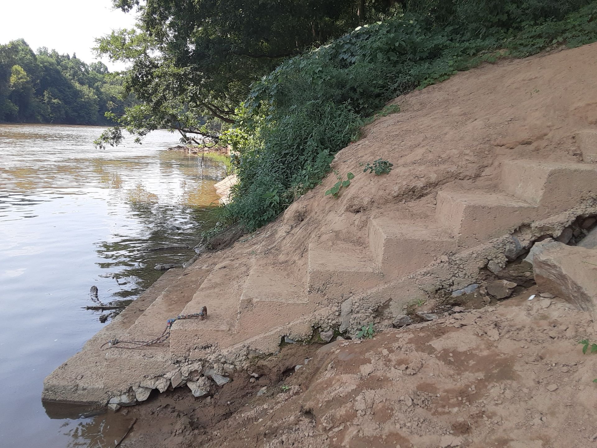
15) Mile 46 - Boone's Cave Park
Address:
GPS Coordinates:
Maintained By:
Phone:
Parking:
Facilities:
Camping:
Entry Type:
Next Access:
Miles to Next Access:
Time to Next Access:
3552 Boones Cave Rd, Lexington, NC 27295
35.799862, -80.468053
Davidson County
336-752-2322
Paved lot
Restrooms, Vending Machine
Allowed
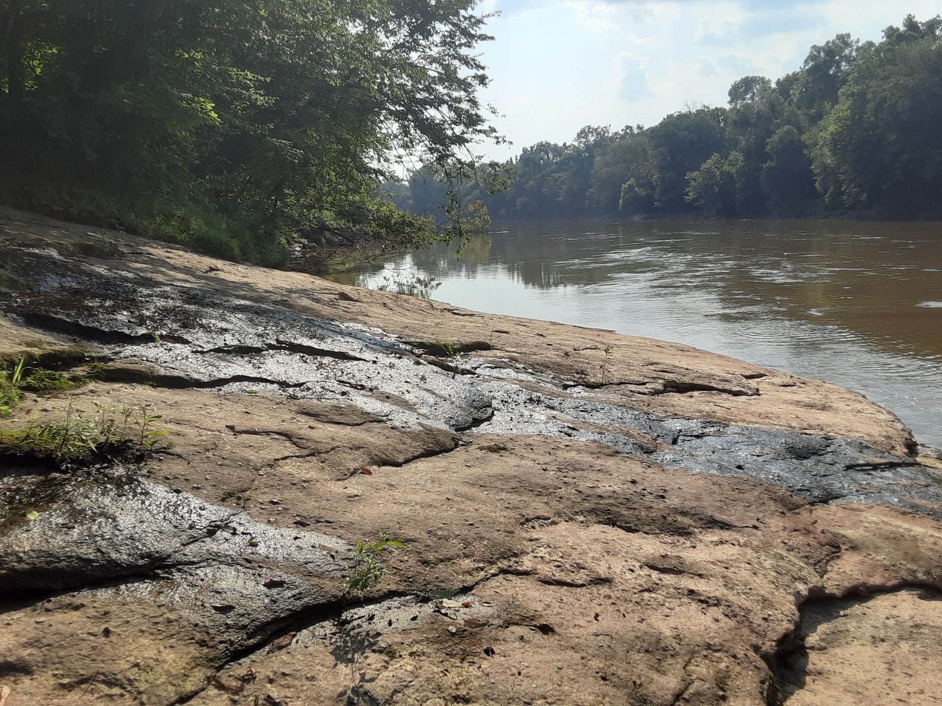
Natural rock slope
Hannah Ferry (South Yadkin River)
4.9 Miles
2 Hours
16) Mile 41 - Hannah Ferry (at South Yadkin River)

Note: must paddle slightly upstream around riverbend on river side right to reach this access point.
Address:
GPS Coordinates:
Maintained By:
Phone:
Parking:
Facilities:
Camping:
Entry Type:
Next Access:
Miles to Next Access:
Time to Next Access:
955 Hannah Ferry Rd, Salisbury, NC 28144
35.746942, -80.461051
NC Wildlife Resources
Small gravel lot
None
None
Concrete boat ramp
York Hill
4.9 Miles
2 Hours
17) Mile 37 - York Hill (Yadkin River Park)

There are two access points: #1 is a concrete ramp for larger boats, #2 is specific for canoes/kayaks.
Address:
GPS Coordinates:
Maintained By:
Phone:
Parking:
Facilities:
Camping:
Entry Type:
1212 Wilcox Way, Linwood, NC 27299
(#1) 35.723981, -80.391099
(#2) 35.725020, -80.390640
Davidson County
(336) 242-2958
Large gravel lot
Porta-Potty
Allowed
(#1) Concrete Boat Ramp
(#2) Hand Carry Natural Slope
York Hill marks the beginning of High Rock Lake. There are multiple boat ramps on the lake, not specific for canoes/kayaks. Paddlers will encounter the High Rock Dam about 15 miles downstream.